


Airport
![]()
WISCASSET MUNICIPAL AIRPORT 882-5475
The Wiscasset Municipal Airport (international identifier: KIWI) is located within the municipal boundaries of the town of Wiscasset, Maine, in Lincoln County, approximately four miles west of the village (central business district). The airport is located on Chewonki Neck Road, south of Route 144 and east of U.S. Route 1. KIWI is approximately 50 miles east of Portland and 12 miles from Boothbay Harbor, Maine and can be accessed by U.S. Route 1 and state highways 27, 144, and 218. The airport’s deeded property, which was acquired over a number of years starting in 1958, covers approximately 257 acres, including avigation easements.
Airport Rules (adopted January 2019)
Addition information about the airport can be found at the following links:
- Airnav.com
- Airport Master Record (FAA Form 5010-1)
- Current Notices to Airmen (NOTAMS) (enter IWI in the Locations box)
- Current Weather (click link or call 207-882-8094)
- www.wiscassetairport.com
Disadvantage Business Enterprise Program (DBE)
Click the link below to view the Policy Statement. The entire Plan can be obtained by contacting the airport manager at (207) 882-5475.
Airport Management and Oversight
The airport’s sponsor (owner/operator) is the Town of Wiscasset.
Dennis L Simmons, Town Manager
Richard Tetrev, Airport Manager
Airport Advisory Committee: The airport advisory committee meets on the third Wednesday of every month at the airport. Minutes of past meetings are located in the minute’s section of the town's website.
Current Prices and Fees (effective May 1,2023)
|
Landing Fee: |
$0.00 |
|
Ramp Fee (aircraft with MGTOW 6,000# or greater): |
$75.00 |
|
Hangar Storage (monthly): |
$300 |
|
Hangar Storage (nightly): |
$35 |
|
Apron Tie Down (monthly): |
$50 W/Electric $75 |
|
Apron Tie Down (nightly): |
$15 W/Electric $25 |
|
Conference Room Rental: |
$50/day (4 hours or longer) $25.00 Half Day |
|
Hangar Land Lease (developed – w/o water/septic): |
$0.22/sf |
|
Hangar Land Lease (developed with water/septic): |
$0.27/sf |
|
Hangar Land Lease (undeveloped): |
$0.10/sf |
|
Aircraft Oil: |
$15.00 Quart |
|
Fuel: |
Guaranteed as posted on Airnav.com |
History
The vision for the airport had its beginnings in 1957 when the town purchased two parcels totaling 106 acres from J.B. Sutter. The following year the town purchased three more parcels from L.H. Grover (25 acres), E.G. & J.E. Getchell (1.4 acres) and A.H. Weeks (14.5 acres). The airport began in earnest in 1958 when the Board of Selectman, headed by 1st Selectman Harold Campbell submitted a grant application to the then Civil Aeronautics Authority (CAA) for the creation of an airport. This early grant was used to pay for the recently acquired land and to begin the design process that would eventually become the airport’s only runway. The airport’s official property map (the one recognized by the FAA) can be viewed by clicking Item # 9 in the ALP section below.
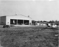
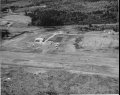
Wiscasset Municipal Airport opened in 1961 (exact date unknown at this time) with a 2,600 foot long turf runway originally designated 4-22. The airport's original hangar was constructed about the same time. Throughout the years since additional land was acquired, the runway extended and a parallel taxiway constructed. Photos of the airport are available below. This table lists various milestones in the history of the airport.
|
Year |
Project |
Notes |
|
1958 |
Land Acquisition |
Harold Campbell, 1st Selectman |
|
Relocation Of Chewonki Neck Road |
Helen C. Erskine, Town Clerk |
|
|
Design Turf Runway |
David Soule, Town Attorney |
|
|
1961 |
Construct Turf Landing Strip |
2,600 feet long x 250 feet wide |
|
|
|
Designated Runway 4-22 |
|
1962 |
Extended And Paved Runway |
Runway now 2,800 feet x 75 feet |
|
Installed Runway Edge Lights |
|
|
|
Constructed Aircraft Apron |
|
|
|
Constructed Stub Taxiway (Apron To Runway) |
|
|
|
1964 |
Apron Expansion |
|
|
1968 |
Runway Extension |
Runway now 3,400 feet x 75 feet |
|
Acquired Land |
|
|
|
Expanded Aircraft Apron |
|
|
|
1975 |
Purchased Land For Non-Directional Radio Beacon |
Site located off Route 27 in Edgecomb |
|
1982 |
Runway Overlay |
Runway now designated 7-25 |
|
1985 |
Airport Master Plan Update |
|
|
1990 |
Town Acquired Terminal Building |
Formerly Weight Watchers Building |
|
1994 |
Conduct Airport Master Plan Study |
|
|
1995 |
Remove Obstructions |
|
|
1996 |
Expand Apron & Construct Taxiway |
Taxiway connects apron to Runway 25 |
|
1997 |
Improve Runway Safety Area |
|
|
1999 |
Airport Master Plan Update |
|
|
2001 |
Acquire Land For Taxiway Extension |
Former Soule Property |
|
2003 |
Extend Taxiway (Design) |
|
|
2005 |
Extend Taxiway (Phase I) |
|
|
2006 |
Extend Taxiway (Phase II) |
Airport now has full length parallel taxiway |
|
2007 |
Replace Rotating Beacon |
|
|
Replace Hazard Beacon |
Whaleback Ridge in Woolwich |
|
|
2008 |
Decommission NDB |
FAA issued formal land release |
|
2009 |
Construct Snow Removal Equipment Building |
|
|
2014 |
Airport Master Plan Update |
Grant approved in 2010 |
|
2014 |
Environmental Assessment |
Grant approved in 2013 |
|
2021 |
Aquired avigation easements |
|
|
2022 |
Reconstructed Runways 7-25 |
Airport Photographs
Airport Master Plan Update
An Airport Master Plan is an exhaustive, airport-wide study with the goal of developing short-, medium- and long-term plans to meet future aviation demand. The specific process is highly variable and dependent on each airport, but the general process includes pre-planning, public involvement, environmental considerations, existing conditions inventory, aviation forecasts, facility requirements, alternatives development, Airport Layout Plan (ALP), facilities implementation plan, and financial feasibility analysis.
Wiscasset Municipal Airport Master Plan was most recently updated in 2014. The study identifies Planning Activity Levels, or “PALs,” that represent future levels of activity at which key improvements are necessary and the study assumes the realization of PAL 1, PAL 2, and PAL 3 in approximately 2015, 2019, and 2033, respectively. The final deliverables for the update are a technical report and an Airport Layout Plan or ALP.
TECHNICAL REPORT
The Master Plan Technical Report contains the detailed technical information for each part of the Master Plan process. The report is available in sections, and require Adobe PDF Reader, which is available free of charge by clicking the link.
- Cover and Table of Contents
- Chapter 1 - Introduction
- Chapter 2 - Inventory of Existing Conditions
- Chapter 3 - Forecasts of Aviation Demand
- Chapter 4 - Facility Requirements
- Chapter 5 - Alternatives Analysis
- Chapter 6 - Airport Layout Plan (Discussion)
- Chapter 7 - Implementation Plan
- Appendix A - Glossary of Terms
- Appendix B - Airport Layout Plan Set (see below)
- Appendix C - Obstruction Analysis
- Appendix 4 - Alternative Designs
AIRPORT LAYOUT PLAN
The Master Plan ALP drawing set graphically depicts the existing and future airport layouts, the obstructions to airspace, standard takeoff and landing zones, runway navigational aids, and property information.
- Title Sheet
- Existing Facilities Plan
- Airport Layout Plan (Recommended Facilities)
- Terminal Plan
- Runway 7 Approach Plan & Profile
- Runway 25 Approach Plan & Profile
- Airspace Plan
- Land Use Plan
- Property Map (Exhibit A)
Airport Environmental Assessment
The airport completed an Environmental Assessment (EA) in July 2014. The purpose of the EA was to document potential impacts associated with acquiring avigation easements and mitigating off-airport vegetative obstructions to Runway 07/25 protected airspace. The FAA issued a Finding of No Significant Impact (FONSI) on August 7, 2014. A copy of the final EA is available by clicking the the link above.